Source: Skyward
Verizon’s drone subsidiary Skyward launched a new feature last week for its drone management platform. The Portland-based company launched its latest automated flight modes for pre-planned missions and surveys on the Skyward Inflight mobile app.
The new modes will allow subscribers to fly automated drone missions, collect imagery, data or videography; and automatically log flights to Skyward without having to leave InFlight. Pre-programmed drone flights can be reviewed before takeoff and the images collected can be processed using any major drone mapping software.
Modes include Survey, Orbit and Point-to-point:
Survey
Subscribers can automatically create a flight path for three-dimensional mapping based on a given area of operation with the survey mode. Survey calculates a flight path along a survey grid and controls the drone as it autonomously flies the mission. Advanced controls give users the ability to fine tune the flight parameters for optimal data collection.
Following the drone mission, collected images can be transformed into 3D maps using a post-processing platform. The data is compatible with most major drone mapping software. “Survey is a great fit for companies conducting orthomosaic or LiDAR point cloud surveys,” a Skyward spokesperson noted.
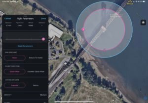
Orbit
Orbit creates an automated path around a point of interest, allowing the user to smoothly capture a video from all angles. The drone’s flight path can be adjusted according to precise parameters for optimal photo or video capture.
Orbit provides 360-degree footage of a site or structure, and the images collected can be used to help create 3D models.
Point to point
With Point to Point, users can create a path of points for the drone to fly along automatically and modify the parameters of the path to optimize the footage collected. Flight crews can plan exact flight paths to execute a mission before deployment. “Point to Point missions can be executed for a diverse array of use cases, including surveying, inspection, and construction progress tracking. It brings the next step toward autonomy into Skyward.”
In a press release, a Skyward spokesperson added:
“With the addition of Automated Flight Modes, Skyward customers can simplify the workflow by managing their entire mission in the field using InFlight. Users can plan flights, request airspace permission, run a risk assessment, and control a flight. Operations in progress can be monitored with live flight tracking. And all your flight logs, whether manually controlled or automated, are automatically saved to Skyward’s Drone Management Platform for later review.”
Last month, Skyward announced the FAA granted the company a temporary waiver allowing company pilots to fly Percepto Sparrow drones from their homes to inspect critical communications infrastructure near the Big Hollow wildfire in Washington.
Jason is a longstanding contributor to DroneLife with an avid interest in all things tech. He focuses on anti-drone technologies and the public safety sector; police, fire, and search and rescue.
Beginning his career as a journalist in 1996, Jason has since written and edited thousands of engaging news articles, blog posts, press releases and online content.
Email Jason
TWITTER:@JasonPReagan
Subscribe to DroneLife here.
https://dronelife.com/2020/10/19/verizons-skyward-adds-features-to-drone-app/